
Features Abots Way
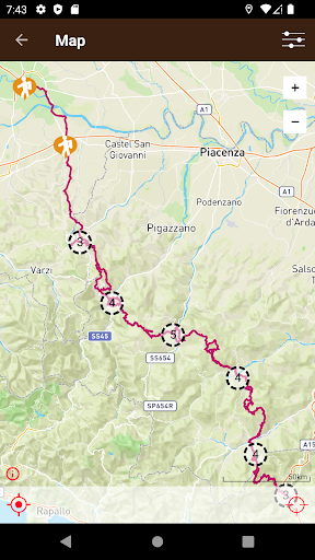
The Abbots Way crosses part of the provincial territory of Pavia and the Tuscan-Emilian Apennines in the provinces of Piacenza, Parma and Massa Carrara, passing through the municipalities of Pavia, Broni, Canneto Pavese, Castana, Montecalvo Versiggia, Colli Verdi, Alta Val Tidone, Romagnese, Bobbio, Coli, Farini, Bardi, Borgo Val di Taro and Pontremoli.The route is about 190 km long and is much more demanding than the more famous Via Francigena.
It winds its way along paths, mule tracks and cart tracks through valleys and ridges with a total height difference of over 6000 metres.
It is marked CAI with horizontal white and red bands.The app “Via degli Abati” helps you find your way along the routes in the area.
The interactive map allows you to view your position on the route via the GPS on the device, even without internet connection: you can download the maps to avoid using mobile data.In case of distraction, an alarm warns you if you stray off the path, and you can report any problems on the routes, automatically communicating the GPS position.The tourist accommodation, services and points of interest along the routes are located on the map, and you can contact them directly from your smartphone.The application "Via degli Abati" is a project of the Municipality of Bobbio with the support of the Rural Development Programme 2014-2020 Measure 19 "Support for LEADER Rural Development" - Specific Action 8.1.1.b "Enhancement of tourist itineraries and trails".
Social Features
Connect and share with friends and the community.
Fitness Tracking
Track your workouts and monitor your health metrics.
Travel Features
Plan and manage your travels with ease.
See the Abots Way in Action
Get the App Today
Available for Android 8.0 and above